App: A bike map and guide for Chicagoland
Consider this: You like to use the Chicago Bike Map but you don't always carry it with you. You want to be reminded of where the bike lanes and trail access points are. But you do carry your smartphone with you, all the time.
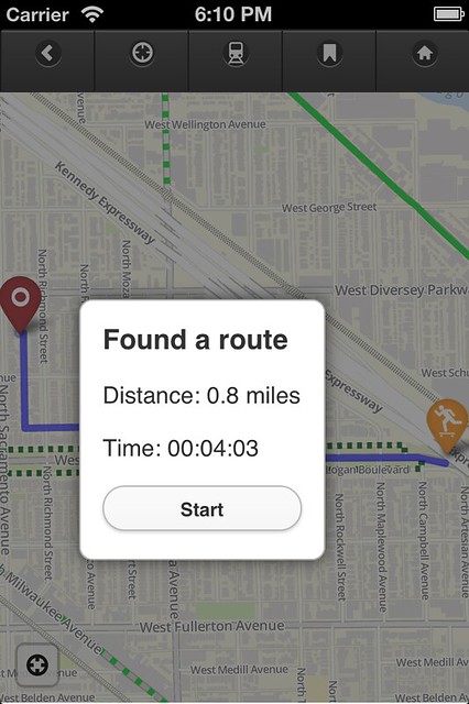
In April 2012 I launched my first-ever app, the Chicago Bike Guide. It works similarly to the "Chicago Bike Map" (the City's printed one) in that it shows the presence of on-street bike lanes, multi-use trails, and train stations. It works like Google Maps, though, where you can pinch and zoom to interact with the map.
Divvy, train stations, directions, The Chainlink, Twitter, points of interest, it's all right here.
Available for Android and iOS.
Views: 3849
Replies to This Discussion
-
Permalink Reply by Steven Vance on
-
New resources coming in the next update, along with more points of interest. DIY bike repair stands upped from 4 to 6 now.
There will be at least one new feature: You will know which CTA stations are "accessible", meaning they have elevators and wide turnstile gates (so you can let you and your bike in and out of the station without a customer assistant).
AND, for a limited time, you can demo the app on any computer. Why a limited time? My server will not be able to support the demand for all of those map tiles. I will likely just provide map tiles for a small area of Chicago at two zoom levels, to maintain the demo and stay under server limits.
-
-
For anyone who's downloaded and used the app, have you run into any problems opening it? I got one report the other day. The person said he used it once and can't use it again. While I gather more info, I've put up a Troubleshooting Tips page that, so far, has a single tip.
I haven't received any crash reports (this has to be something enabled in the Settings app).
-
-
New release, version 0.5, brings a lot of new features and updates, including:
- 9 multi-use trails in the region
- Evanston bike lanes
- Latest new Chicago bike lanes (only ones that are complete and not under construction)
- Bookmarking feature
- Location search (requires internet)
- Some Twitter #bikeCHI integration
- Compatible with iPhone 5's taller screen
- Suburban CTA and Metra stations
- Smaller file size
Learn more. Buy now in iTunes.
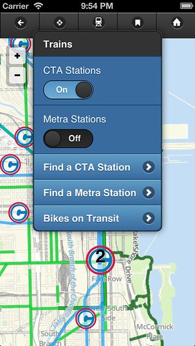
Screenshot shows new CTA station icon and how you can toggle CTA and Metra individually.
-
Permalink Reply by Lee Roy on
-
Nice Job!!! Thank you for putting the Des Plaines River Trail in there. And now the map touches my new place in Des Plaines! Pretty exciting stuff IMHO.
-
Permalink Reply by David Barish on
-
Is an android version still on the horizon?
-
Permalink Reply by Far'arned Retrogrumpalunkus #63 on
-
+1
David Barish said:Is an android version still on the horizon?
-
-
I will give it one more try. The first time I tried, I followed all of the instructions to set up the development environment on my computer and then when I tried to simulate the app, I couldn't resolve them.
David Barish said:Is an android version still on the horizon?
-
Permalink Reply by daWillinChi on
-
Do you have a feature to report a specific situation? Like pot-holes, or road under construction, in your app?
This would be a nice feature to have. Click on an icon that takes you directly to a location of where you are and a memo pad to write the report and has a send button to send to you to report the situation. Or just tweet with the current location attached
-
Permalink Reply by David Holmquist on
-
+2
David Barish said:Is an android version still on the horizon?
-
-
That feature doesn't exist but now I may attempt to include it in a future revision. One issue that I feel must be resolved before this happens is that there must be a destination for this report and a process for something to be done about it.
The City of Chicago has an #open311 API that means programmers can directly insert into the 311 database a report, allowing users of these apps to bypass calling 311 and waiting on the phone for 4+ minutes.
There are currently only 14 request types available in the API, four of which I feel are directly relevant to Chicago bicyclists: potholes, street cuts, traffic signal out, and pavement cave-in. I have requested that these 40 be available. The Chief Technology Officer and I have started a discussion on how to make that possible; he says it takes substantial work to make a new request type available in #open311.
At the very least, I may try to adapt my app to work with existing apps and websites that hook into #open311 (Chicago Works iPhone app, SeeClickFix website).
There's not a method to use Twitter to accept requests for service.
Just Will said:Do you have a feature to report a specific situation? Like pot-holes, or road under construction, in your app?
This would be a nice feature to have. Click on an icon that takes you directly to a location of where you are and a memo pad to write the report and has a send button to send to you to report the situation. Or just tweet with the current location attached
Groups
-
Critical Mass discussion
262 members
-
Chicagoland Beer Explora…
203 members
-
Chicago Randonneurs
269 members
-
Walk Bike Transit
63 members
-
British Bicycles of Chic…
172 members
© 2008-2016 The Chainlink Community, L.L.C.
Powered by
![]()